
- greymanadmin
- 23/09/2026
Audit-grade thermal cattle stocktake
Count every head.
Without moving one.
We fly your feedlot overnight by thermal drone, count every animal by heat signature with AI, and reconcile the result to your register — a defensible headcount to Big-4 audit standard. No mustering, no crew in the pens, no guessing.
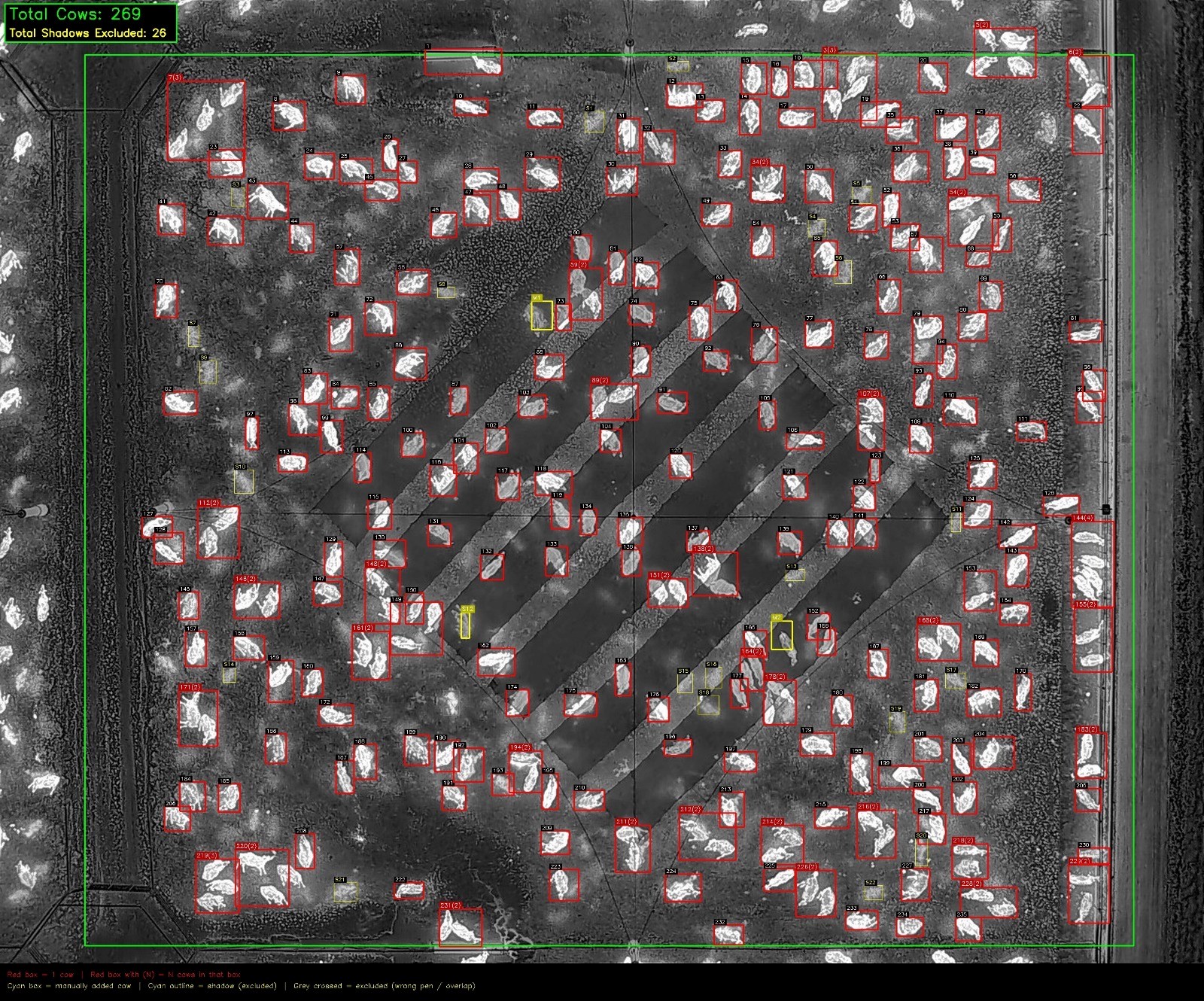
Live AI thermal count — 269 head counted in this capture, 26 shadows excluded. (Client anonymised.)
Every penimaged & counted, one clear frame each
1 nightautonomous overnight capture window
24 hrsgeotagged register delivered
Big 4audit-standard outputs
What it is
A counted number — not an estimate
Cattle hold heat, so at night every animal lights up against the cool ground. We fly an autonomous thermal drone over your feedlot while stock are settled, capturing one clear frame of every pen. Our AI counting pipeline then works pen by pen: it boxes each animal, separates animals that share a frame, and identifies and excludes warm shadows and ground artefacts — so nothing is missed and nothing is counted twice. The result traces back to a specific, located, time-stamped image: the kind of evidence your auditor, financier and insurer will accept.
| How it compares | Thermal night drone | Pen riders | Helicopter | Day drone |
|---|---|---|---|---|
| Finds every animal (no shadow/mud misses) | Yes | Varies | Varies | No |
| Animal welfare (stock stay settled) | High | Low | Low | Med |
| Double-counting controlled | Yes | Hard | Hard | Some |
| Auditable image evidence per pen | Yes | No | No | Some |
| Speed & labour | Fast | Slow | Fast/costly | Med |
| Safety (no crew in feedlot / low-level air) | High | Med | Low | High |
The process
From flight plan to audited headcount
1
Map & reconcile
We map the feedlot to survey grade and reconcile every pen to your register — one waypoint per pen, agreed in writing.
2
Plan the route
An autonomous, RTK-positioned flight path over every pen — one clear thermal frame each, in sequence.
3
Fly overnight
The drone flies the count while cattle are settled — every animal reads by heat signature, no crew in the feedlot.
4
Count & report
AI counts each pen, shadows excluded; a geotagged register reconciled to your book figure within 24 hours.
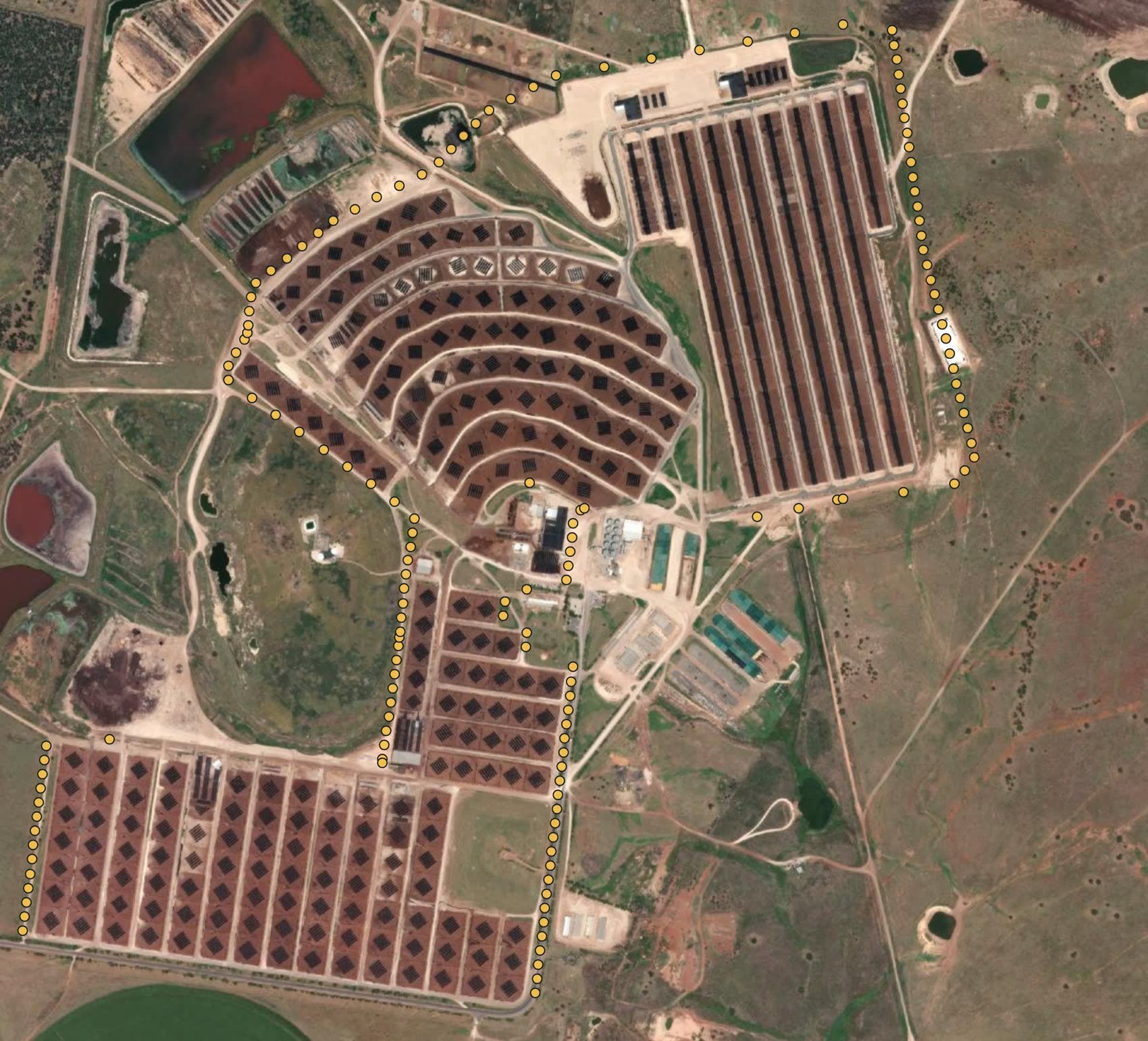
Planned capture waypoints over a feedlot, flown autonomously in sequence. (Location anonymised.)
Coverage you can prove
One waypoint. One pen. Every time.
Before we fly, we build a capture mission with a waypoint over every pen — sequenced and reconciled to your register. The aircraft flies the route autonomously, stops at each pen and captures one clear thermal frame. Then we cross-check the imagery against your pen list. Every pen is accounted for — or we re-fly it. That is the difference between an estimate and an audit-grade count: coverage you can prove, pen by pen.
What you receive
Deliverables built for audit
- Planned Waypoint Register + flight-path map — every pen sequenced, with waypoint, lat/long and planned altitude.
- A clear, geotagged thermal image of every pen — decimal-degree GPS in the metadata, each frame named to its Pen ID.
- Per-pen count table + visual count map — counts overlaid on a survey-grade map of your feedlot.
- Capture Register within 24 hours — timestamp, photo ID and notes per pen, plus a non-conformance log.
Total data transparency
No black box. Every image we deliver is GPS-logged, so any number in the count traces back to a located, time-stamped frame — open any pen and see exactly where and when it was captured.
Latitude / LongitudeWGS84 decimal degrees, in every image
Height (AGL)above-ground altitude of capture
Waypoint & Pen IDevery frame tied to its pen
Timestampdate & time of capture
RTK-positionedsurvey-grade accuracy
Who we are
Greyman OPS
Commercial drone operations, supply and support — and specialists in thermal survey, mapping and biosecurity. We run every job under our own CASA certification, so clients need no accreditation of their own.
Commercial drone operations, supply & support
Managed drone operations under our own ReOC, plus DJI Enterprise sales and ongoing support — from a single count to a standing program.
Biosecurity & wildlife management
Thermal survey and aerial capability for pest and wildlife management, environmental monitoring and biosecurity across rural operations.
Why Greyman OPS
Own CASA ReOC 9077 — fly under our umbrella, no client cert needed
BVLOS approval in progress
A$20M Public Liability · A$2M Professional Indemnity
100% operational safety record since 2018
In-house thermal, mapping & AI counting
National coverage
Request a quote
Tell us about your feedlot
Give us your pen count and rough timing and we'll scope a count for your feedlot. The more you tell us, the tighter the estimate.
Talk to us directly
Email — ops@greyman.com.au
Scan or visit
Thanks for stopping by at BeefEx, happy to scope a thermal count for your yards.
Greyman OPS · Audit-grade thermal cattle stocktakes
ops@greyman.com.au · · www.greyman.com.au/feedlots
CASA ReOC 9077
A$20M Public Liability · A$2M Professional Indemnity · 100% safety record since 2018
Count and imagery from a Greyman OPS thermal stocktake; client and location anonymised for confidentiality. The 269-head figure is the AI count for the capture shown, not a whole-of-site total. © 2026 Greyman OPS · Clearwater CFA Pty Ltd t/a Greyman OPS · ACN 619 194 964.
FAQ
Frequently asked questions
How does a thermal drone cattle stocktake work?
A drone with a high-resolution thermal camera flies over the pens, usually early morning, and every animal is counted from the imagery and reconciled to your register.
Does it disturb the cattle?
No. Flights are high enough that cattle are not disturbed and no mustering or yarding is needed.
Where do you operate?
Feedlots across Queensland, NSW, Victoria, SA and the NT.
Greyman OPS · CASA ReOC 9077 · $20m insured
Book a thermal stocktake
Audit-grade overnight counts with GPS-tagged reports, recognised by Big 4 audit firms.